California has such a beautiful range of oak trees scattered across the state parks. Here are a few shots of some of these majestic trees.


Tuesday, May 15, 2007
California Oaks
Sunday, March 25, 2007
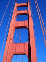
Sunny San Francisco
Some photos of the Golden Gate Bridge. Its always fun walking across the bridge and back, taking in spectacular views of the city on one side and the Marin Headlands on the other.


Wednesday, January 24, 2007
Visiting Forts and Palaces: Jaigarh and Nahargarh, Jaipur
 I've always been fascinated by Rajasthan. Images of maharajas and maharanis, palaces, forts, elephants and camels float through my mind. So I decided to visit two of the most enchanting fortresses around Jaipur - Jaigarh and Nahargarh. High above Jaipur, the city's noise and pollution are almost forgotten. The commanding heights of these forts invite Rajasthan's dry winter to bring its crisp clean air and shower all with brilliant sunshine.
It took about five hours to reach the Amer area of Jaipur from Delhi. Both Jaigarh and Nahargarh are approached from the same road that cuts through the hills and ravines near Amer (Amber) Palace. The scenery was spectacular as we wound our way upwards. Jaipur with its Jal Mahal could be seen in the distance. Amber Fort and Palace were below at our feet. Brown hills and the City of Jaipur glistened in the sun beyond.
Jaigarh
 Langur monkeys, the distractable sentries of the modern era, greeted us at the gates of Jaigarh. The fortress's immense walls stared at us up close, forbidding and inviting at the same time. Cars are allowed inside the 1100 year old fort complex with a parking permit.
The "Jaivana" cannon, the world's largest cannon on wheels, could be seen as soon as we entered. We walked the perimeter of the fort on walls which are thick enough to allow an elephant to saunter through. We ambled through different sections of the fort -
 approaching from above the reservoir where the soldiers who lit the fuse for the Jaivana had to hide to escape its booming noise. We circumabulated the Shiva temple and explored the inner palace where the king and his courtiers used to discuss strategy and war as well as entertain themselves. The palace within the fortress flaunted its gorgeous gardens, fountains, durbar halls, courtyards, dining halls,
  kitchens, a puppet theater, with stunning views of the sky, and elaborate living quarters. Among ancient hills and valleys, Jaigarh offered an amazing journey back into time. After enjoying a late afternoon picnic, we wished we had more time to visit the museum of the fort. The museum highlights the metal work of the resident foundry: an endless parade of guns and ammunition from the era of Rajputs.
Nahargarh

 Nahargarh fort, built in 1734 by Sawai Raja Jai Singh, is situated on the ridges of the rolling Aravalli range. An enchanting mix of colors has been used for intricate hand painted wall designs throughout the palace rooms. A striking combination of pastels with woodwork and mirrors embodies the hallmark of Rajasthani architecture. Courtyards and hallways, cool and serene, were all part of the excitement of wandering through these lost places in time. The bells of the Nagesh (king of the "nagas" snakes) temple on the perimeter of the fort invited a steady stream of visitors.
 Both forts offered views from the Aravalli ridges that are simply breathtaking. The sight of Man Sagar lake in which the Jal Mahal of Jaipur stands was spectacular in the glowing sunset.
These forts and palaces make great treks for short excursions. Lots to see and enjoy!
Sunday, January 7, 2007
Seine-sational!
A walk on the banks of the Seine is a pleasure at any time of the year and especially invigorating in winter when the quays, ponts and river banks are less packed with tourists. 
 Along narrow riverside parks, grand town houses and monuments stand witness as barges glide silently by on the grey winter waters of the Seine.
The Seine flows through the heart of Paris dividing the city into its left and right banks. Starting on the left bank at Champ De Mars, under the Eiffel Tower, I crossed the Seine at Pont d'lena.

While stopping to admire the bateaux mouches on the water, my journey took me past the Trocadero, Pont de l'Alma towards Pont de la Concorde. Strong winds and cloudy skies added to the briskness of the trek across town. Pont Alexandre III in the Invalides quarter stood out as a jewel among the many bridges in Paris. Its gilded statues and ornate carvings complement the grandeur of Paris. On reaching the massive square at Place de la Concorde, the 3200 year old obelisk from Luxor, Egypt, reached out in the midst of fountains and intersecting roadways all around. From the base of the obelisk, the Avenue de Champs De Elysees leads to the Arc de Triomphe in the distance - a view worth a mille mots.
 Appreciation of Paris is incomplete without visiting one of the world's great museums - the Musee du Louvre.
  Its entrance, the famous glass pyramid by American architect I M Pei, accents the central courtyard. The Louvre's historic buildings, spread along the right bank, house treasures which include the fantastic Egyptian, Babylonian and Greek antiquities collections. In the European painting collections, the Mona Lisa and other paintings by Leonardo da Vinci beckon the visitor.
 Meandering through Ile De La Cite and Ile St-Louis is essential for truly capturing the spirit of Paris along the Seine. Crossing into Ile De La Cite on Pont Neuf to enjoy a view of the city overlooking the Square du Vert-Galant was just the start to an adventure through the narrow streets of the islands. The Celtic tribe, Parisii - from whose name the city's own is derived - inhabited this island over 2,000 years ago.
 This is the oldest spot in Paris and places to see include the Notre-Dame, Palace de Justice, Sainte-Chapelle, Hotel Dieu, the statue of Charlemagne and the Crypte Archeologique.
 I especially enjoyed walking through the Marche aux Fleurs et Oiseaux, Paris' main flower market, taking in the colors and fragrances at every turn. Farther along, Ile St-Louis is just south of Ile De La Cite, connected by Pont St-Louis. This quaint corner is full of boutique shops with vibrant window displays of toys, artwork, and masquerade party masks.
Next time, we'll visit other quarters of the city - the Marais, Les Halles, Montparnasse and more.

 Along narrow riverside parks, grand town houses and monuments stand witness as barges glide silently by on the grey winter waters of the Seine.
The Seine flows through the heart of Paris dividing the city into its left and right banks. Starting on the left bank at Champ De Mars, under the Eiffel Tower, I crossed the Seine at Pont d'lena.


While stopping to admire the bateaux mouches on the water, my journey took me past the Trocadero, Pont de l'Alma towards Pont de la Concorde. Strong winds and cloudy skies added to the briskness of the trek across town. Pont Alexandre III in the Invalides quarter stood out as a jewel among the many bridges in Paris. Its gilded statues and ornate carvings complement the grandeur of Paris. On reaching the massive square at Place de la Concorde, the 3200 year old obelisk from Luxor, Egypt, reached out in the midst of fountains and intersecting roadways all around. From the base of the obelisk, the Avenue de Champs De Elysees leads to the Arc de Triomphe in the distance - a view worth a mille mots.
 Appreciation of Paris is incomplete without visiting one of the world's great museums - the Musee du Louvre.
  Its entrance, the famous glass pyramid by American architect I M Pei, accents the central courtyard. The Louvre's historic buildings, spread along the right bank, house treasures which include the fantastic Egyptian, Babylonian and Greek antiquities collections. In the European painting collections, the Mona Lisa and other paintings by Leonardo da Vinci beckon the visitor.
 Meandering through Ile De La Cite and Ile St-Louis is essential for truly capturing the spirit of Paris along the Seine. Crossing into Ile De La Cite on Pont Neuf to enjoy a view of the city overlooking the Square du Vert-Galant was just the start to an adventure through the narrow streets of the islands. The Celtic tribe, Parisii - from whose name the city's own is derived - inhabited this island over 2,000 years ago.
 This is the oldest spot in Paris and places to see include the Notre-Dame, Palace de Justice, Sainte-Chapelle, Hotel Dieu, the statue of Charlemagne and the Crypte Archeologique.
 I especially enjoyed walking through the Marche aux Fleurs et Oiseaux, Paris' main flower market, taking in the colors and fragrances at every turn. Farther along, Ile St-Louis is just south of Ile De La Cite, connected by Pont St-Louis. This quaint corner is full of boutique shops with vibrant window displays of toys, artwork, and masquerade party masks.
Next time, we'll visit other quarters of the city - the Marais, Les Halles, Montparnasse and more.
Wednesday, October 4, 2006
Back in Time at Pyramid Lake, Nevada
Living in the Bay Area inspires one to enjoy nature. This past weekend, I decided to cross the imposing Sierra Nevadas to visit Pyramid Lake, one of the world's most beautiful desert lakes in neighboring Nevada.
 While google mapping directions to Pyramid Lake, I also found Wikipedia's page a good start to understanding the area. Pyramid Lake (approx. 188 square miles) is the largest remnant of Lahontan Lake, an ancient ice-ages lake covering almost all of modern day Nevada (approx. 8450 square miles). The lake is on the Paiute Indian Reservation and is fed by the Truckee River which brings water and silt from Lake Tahoe in the close-by Sierra Nevada mountains.
It took 5 hours to get to Pyramid Lake with a brief halt in Reno. The lake is about 30 minutes from Reno. We decided to take local route 445N (also known as Pyramid Way) through Sparks. The scenery was awesome - the mountains with varied textures of yellows, browns and greens with the bright blue sky above were sheer enjoyment. The weather was perfect with a mild breeze and temperatures hovering around the 70s.
 On entering the reservation, Pyramid Lake emerges on the right. It's a huge, blue mass of water shimmering right next to the 8000' Pah Rah mountains. The Pyramid is strikingly visible, emerging from the lake along with Anaho Island next to it. Anaho Island is home to endangered white pelicans and is off-limits to preserve their habitat.
The primary road for driving alongside the water is on the western shore of the lake through Sutcliffe. The paved road ends a little beyond Warrior Point. The Virginia mountains on the west run next to Pyramid Lake with the scenic route between the hills and the water.
Phenomenal calcium carbonate deposits called "Tufas" form sculptures of nature around and in the lake. Tufas can be seen on the west side of the lake at Pelican Point, Warrior Point, Blanc Tetons, Indian Head Rock, and Popcorn Rocks. Needles Rock on the north end of the lake has a cluster of fascinating thinolite rock forms that jut out of the lake. This area is now off-limits to visitors due to recent vandalism.
 The eastern shore of Pyramid Lake is harder to access. There is only a dirt road (more suitable for trucks than cars). Here there are famous tufas including the Stone Mother Rock, George Washington Rock, Dog Head Rock.
The Paiute Indians run fish hatcheries on the reservation to restock the endangered Cui-ui and Lahontan Cutthroat Trout. Fishing season at Pyramid Lake is from October 1 through June 30 and requires a daily use permit. Camping and boating are allowed year round. The reservation has three towns - Sutcliffe, Nixon and Wadsworth with a ranger station at Sutcliffe. Nixon is the capital and has a high school, health center and  visitor center. A gas station and mini-grocery store called "the Nixon Store" is at the junction of 446 (Sutcliffe Hwy) and 447 (N & S). Hwy 447 S is the route back to Reno. It exits the reservation after Wadsworth. The Truckee River feeds Pyramid Lake from the south and its shallow canyon can be seen running along I-80 W.
The colors and textures of the landscape and the hues of the setting sun accompanied us as we headed back to Reno.
Sunday, October 1, 2006


Subscribe to:
Posts (Atom)


